


Flying Scotsman | UAS

Drone Mapping and 3D Modelling Service in Inverness, Scotland


Mapping And 3D Modelling
Discover the benefits of using drones for mapping and 3D modelling with the latest technology. With high-resolution aerial imagery and precise data collection, drones allow for fast, efficient, and cost-effective mapping solutions.
Whether you need to survey a large construction site, create an accurate 3D model of a building or landscape, or gather topographical data, drones equipped with advanced mapping technology can get the job done in no time. The resulting maps and models are not only highly detailed but also provide an overall better understanding of the environment.
Take your mapping and modelling to the next level with the power of drones.
Contact us today to learn more and see how we can help you achieve your mapping and modelling goals.


"We recently hired Flying Scotsman Productions to conduct drone mapping of our new site, and I am extremely satisfied with their work. Scott's team was professional, efficient, and knowledgeable, and the drones were equipped with state-of-the-art technology to provide detailed and accurate mapping of our site. The final product was delivered in a timely and organized manner and removed the need for any lengthy ground surveying. The drone mapping allowed us to gain valuable insights into the layout and features of our site and will be an essential tool for future planning and development. I highly recommend Flying Scotsman Productions for anyone seeking drone mapping services, and will be using them again in the future."
Services
Drone Mapping
Service
Drones offer a multitude of benefits for mapping and 3D modelling, from improved safety and efficiency to cost-saving measures, drone inspections are revolutionizing the way inspections are conducted.
Some of the key advantages include:
-
Speed and Efficiency: Drones can cover large areas quickly, reducing the time required for traditional mapping methods. They can also reach difficult-to-access locations, making it easier to gather accurate data.
-
High-Resolution Imagery: Drones equipped with advanced cameras can capture high-resolution aerial imagery, providing detailed images that can be used for mapping and modelling purposes.
-
Cost-Effectiveness: Compared to traditional mapping methods, using drones for mapping and modelling can be significantly more cost-effective. Drones eliminate the need for expensive equipment and specialized personnel, and can also reduce travel costs associated with ground surveys.
-
Increased Safety: Drones can be used to survey hazardous or dangerous locations, reducing the risk to personnel. This is especially important in industries such as mining, oil and gas, and construction.
-
Improved Data Accuracy: With the ability to capture high-resolution images and collect precise data, drone mapping and modelling result in more accurate maps and models, providing a better understanding of the environment.
-
Versatility: Drones can be used in a variety of industries, including construction, mining, agriculture, and real estate. The versatility of drones allows them to be used in a range of mapping and modelling applications, from topographical surveys to 3D building models.
In conclusion, drone mapping and modelling provide a fast, efficient, cost-effective, and accurate solution for mapping and modelling needs.
Contact us today and embrace the power of drones and see the benefits for yourself!

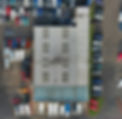
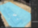
Orthomosaic
Large Scale Mapping
Building inspections are crucial for ensuring the safety and longevity of a structure. But traditional inspection methods can be time-consuming and limited in scope.
That's where drone-created orthomosaics come in.
An orthomosaic is a high-resolution aerial map created by stitching together multiple images taken by a drone. This technology offers the following benefits for building inspections:
-
Comprehensive Overview: Orthomosaics provide a complete and detailed view of the entire building, from roof to foundation.
-
Enhanced Safety: Inspections can be done from the air, reducing the need for workers to perform dangerous inspections.
-
Improved Efficiency: Orthomosaics can be created in a fraction of the time it takes for traditional inspections.
-
Increased Accuracy: High-resolution images captured by drones provide precise and accurate data for inspections.
-
Access to Hard-to-Reach Areas: Drones can easily access hard-to-reach areas, such as rooftops, providing a complete inspection.
Get the full picture of your building with a drone-created orthomosaic. Contact us to schedule your inspection today.
Some Of Our Clients


Precision Software
Pix4D
Pix4D is the industry-leading software solution for drone mapping and modelling, providing unmatched benefits for ground surveys. With Pix4D, you can efficiently and accurately survey large areas, gather precise data, and create detailed maps and models.
Some of the key benefits of using Pix4D for ground surveys include:
-
High Accuracy: Pix4D uses advanced algorithms to process aerial imagery, providing highly accurate results with minimal human intervention.
-
Increased Productivity: Pix4D automates the mapping process, reducing the time required to conduct ground surveys and freeing up time for other tasks.
-
User-Friendly Interface: Pix4D has a user-friendly interface that makes it easy for users of all skill levels to process and analyze data.
-
Flexibility: Pix4D supports multiple data inputs, including imagery from drones, aircraft, and satellites, making it a versatile solution for all mapping and modelling needs.
-
Integration with Other Software: Pix4D seamlessly integrates with other software, such as GIS and CAD, to provide a complete mapping and modelling solution.
-
Support for Multiple Industries: Pix4D is used in a variety of industries, including construction, mining, agriculture, and real estate, providing solutions for a wide range of mapping and modelling needs.
-
Cloud-Based Online Client Portal: The password-protected online portal allows you to have access to your data from anywhere in the world.
Contact us today to learn more and start maximizing the benefits of drone mapping and modelling with Pix4D.
Here Is What Our Clients Say About Us

“We can’t thank Scott enough for the professional drone footage he put together for D & E Coaches.
We are able to see a live view of what the drone sees and sets the whole scene in one shot, of the beautiful scenery of the “Highlands” alongside our fleet of Vehicles – the drone captured it all”
D&E Coaches

“We were delighted with the quality of drone video provided by Scott MacDonald and would highly recommend his service.
His drone was terrific for capturing aerial shots of the Inverness Golf Course and the film he put together was superb"
Inverness Golf Club


